Sinkholes are depressions in the ground that are linked to the collapse of an underground void. Areas that have sinkholes are known as karst terrain or karst topography. How does karst form? There are several steps, starting with the geology:
Calcite (below left) is a mineral composed of calcium carbonate (CaCO3) – similar to the chemical in baking soda. Like baking soda, when vinegar or another acid is added, the calcium carbonate dissolves. Typically the bedrock underneath an area with sinkholes is made of limestone (below middle) which is composed of calcite. Sandstones that contain calcite (below right) also can be susceptible to sinkhole formation.
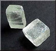
Calcite crystals (above) – the main component of limestone. Photo from USGS. Click here to read more about the mineral properties.
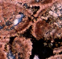
Peloid limestone of the Smackover Formation – pinkish orange crystals are calcite.
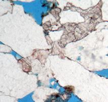
Sandstone of the Donovan Sand– white areas are quartz and feldspar grains and light pink is calcite cementing the grains together.
Rainwater is naturally acidic – not only do raindrops pick up carbon dioxide and sulfur from the atmosphere, they also become more acidic as the water interacts with vegetation. As water moves through the ground and into cracks and crevices of the underlying bedrock, the weakly acidic water dissolves the rock. As dissolving continues, the cracks and crevices become larger, forming caves and caverns.
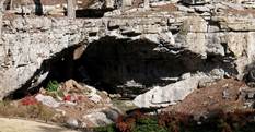
What does a karst area look like underground? See video Sometimes the subsurface has small voids, and other times it may have larger voids such as caves. Click on the movie to the right to see an example of a cave in an Alabama karst area just north of Birmingham.
Click here to go to the National Speological Society homepage to learn more about caves.
When the roof of the cave becomes too thin to support the weight of the ground above, the roof collapses. If the ground above is thin enough, this subsurface collapse can be seen at the surface (below) – this is what we see as a sinkhole.
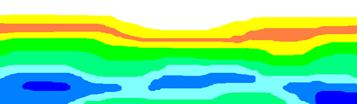
Example of what sinkholes look like on a topographic map. Sinkholes and other depressions are marked by closed contour lines with hatch marks. Not always perfectly round, some sinkholes may be elongated such as the one in the upper right corner. Other sinkholes may swallow streams or be filled with water such as the one to the right of “Hollow”.
Sinkholes can form from a variety of causes including natural and man-made activities and include ground collapse related to:
Click the U.S. Geological Survey map above to see a poster on engineering aspects of karst in the U.S.
Karst areas can be found around the U.S. and there are many techniques engineers can use to help assess sinkhole growth and voids underground. Ground penetrating RADAR (GPR) and resistivity are two methods used to help see what is occurring under the surface. The example below shows a cross section of sinkhole area imaged by resistivity – blue areas represent voids in the rock.
In Alabama, the most common causes of land subsidence are the development of sinkholes in areas underlain by soluble carbonate rocks or ground collapse above abandoned mines. Many areas of the state, particularly north Alabama, are underlain by carbonate rocks, such as limestone, that are susceptible to dissolution and the formation of caves and sinkholes.
I have a sinkhole! What do I do?
To explore sinkholes and other ground depressions in your area, refer to the interactive map (below and here). The points on this map represent topographic depressions on 1:24,000-scale USGS topographic maps. While most of the topographic depressions in karst areas are related to sinkholes, depressions in other areas be related to mine subsidence (in areas with underground mines), surface water erosion (along rivers), or potential storm water washouts (in cities). Also, due to intrinsic limitations of topographic maps, not all sinkholes present in real life are represented on the maps.
*Please note that this interactive map and its related geospatial data is for educational use and reference only and is not meant for use in site-specific evaluations. To download GIS shapefiles and metadata associated with the map, click here.
Newsome Sinks area of Morgan County on the Newsome Sinks 1:24,000 quadrangle map overlain with 2006 aerial imagery.
The topography of northern Alabama is dappled with sinkholes, springs, and cave openings – all features of what is referred to as karst topography. Of particular interest is the Newsome Sinks area in Morgan County. This topography is comprised of coalescing sinkholes and represents the longest karst topographic feature in the state – a little over 4 miles long! This area is underlain by the Mississippian age Bangor Limestone.
Newsome Sinks area of Morgan County on a 1:100,000 topographic map overlain with geology. Blue areas are Bangor Limestone.
The Newsome Sinks area and much of northeastern Alabama is part of the Tennessee-Alabama-Georgia karst area that cavers call TAG. Click here to see some amazing TAG photos and read a National Geographic article featuring this karst area.
The largest sinkhole in Alabama developed near Calera in Shelby County in December 1972 and has been called the “Golly Hole.” A local resident heard what sounded like trees crashing during the night. The following day, hunters in the area discovered a large sinkhole - about 325 feet long, 300 feet wide (roughly a football field length across!), and 120 feet deep. This sinkhole occurred during a drought when the water table was much lower than normal.
This particular area of Shelby County has had a history of sinkhole development and is underlain by soft limestones. Previous research indicates hundreds of historical collapse features within a 16- square-mile area (Warren and Wielchowsky, 1973). Most of these historical and recent sinkholes are within the Dry Valley which is underlain with deeply weathered Cambrian dolomites of the Knox Group.
To read more on the Golly Hole and its related geology, see the below references:
LaMoreaux, P.E. and Warren, W.M., 1973, Sinkhole: Geotimes. v. 18, no. 3, p. 15.
Warren, W.M. and Wielchowsky, C.C., 1973, Aerial remote sensing of carbonate terranes in Shelby County, Alabama: Groundwater, v. 11, no. 6, p. 14-26.
To download geology shapefiles for the Alabaster Quadrangle geologic map, click here.
The "Golly Hole" in Shelby County as shown on aerial imagery (above-left), the 1:24,000 Alabaster topographic map (above-middle), and photo from the ground (photo by Tom Stone).
A ground depression (like a sinkhole) can be caused by a variety of geologic and non-geologic issues including drainage, abandoned water wells, buried construction material, septic tank collapse, water or sewer line leaks, as well as other area-specific issues.
What to do or who to call may depend on the cause of the depression. Below are some actions to consider when dealing with a depression on your property:
Home affected by developing sinkhole in the Birmingham area.
* Due to budgetary and staffing constraints, GSA does not perform site visits to evaluate sinkholes. GSA also does not mitigate or repair sinkholes.
Did you know that sinkholes are protected in Alabama? Because sinkholes are a direct conduit to the groundwater, any contaminants dumped into a sinkhole may end up in the groundwater. About 40% of public water supplies in Alabama are from ground-water sources and 27 south Alabama counties receive all of their public water supplies from ground-water sources. Since much of Alabama gets their water from groundwater resources, it is important to protect the groundwater quality, and therefore sinkholes too. The below information lists some of the regulations related to karst, caves, and sinkholes in the state of Alabama.
Specifically, the Alabama Cave Protection Law of 1988 states that “It shall be unlawful and constitute a misdemeanor for any person, organization, firm, corporation, including any officer, employee or agent of any town or municipality to risk the pollution of the underground water resources of the state by storing, dumping, disposing, or otherwise placing in caves, sinkholes or natural wells: chemicals, refuse, dead animals, garbage or other materials which are potentially injurious or hazardous to the quality of the aquifer, water and/or water table.” Alabama Cave Protection Law (1988), (Acts 1988, No. 88-582, p. 909, §4.), Section 9-19-4. Click here to go to the Alabama Legislative Information System Online to read the full text.
Additional regulations from the Alabama State Board of Health’s Division of Community Environmental Protection relate to onsite sewage treatment and disposal with respect to sinkholes and planning: Administrative Code Chapter 420-3-1.