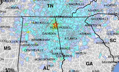
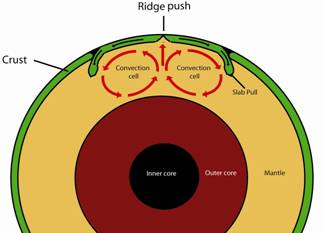
Earthquakes occur around the globe, on every continent and even in the ocean floor. In the maps to the right and below, you can see that earthquakes cluster in particular locations. Most of these areas of high earthquake activity are on plate boundaries. Other earthquakes occur within plates (called intraplate earthquakes). All of Alabama’s earthquakes are intraplate.
Below is SeismicMonitor – a product of the Incorporated Research Institutions for Seismology (IRIS) and the U.S. Geological Survey (USGS) showing real-time global earthquakes of magnitude 4.0 and greater over the last five years. To learn more about a particular quake on the map, click on the epicenter. To see USGS realtime earthquakes in GoogleEarth, click here.
The outermost layer (crust) of the earth is divided into huge plates, like a cracked eggshell. Heat generated in the core is transferred into the mantle, a slow-moving plastic layer that drags the overlying crustal plates (left). Stress builds up along plate boundaries and within plates.
This can pull or push the crust forming different structural features such as:
When stress exceeds the strength of the rocks in the crust, the crust breaks along a fault and snaps into a new position. This sudden movement releases energy—what we know as an earthquake.
Instruments that measure magnitude of earthquakes are seismographs (or seismic stations). Seismic stations sense and record vibrations from earthquakes as well as other sources such as mine collapse, quarry blasts, explosions, construction, and even sonic booms from aircraft or the space shuttle.
In order to more clearly sense earthquake waves, seismic stations must be buried in hard rocks (right). This allows the station to pick up seismic waves from around the world. To see examples of seismograms (such as the one in the header of this page) from USGS seismic stations, click here.
Interested in learning more about seismographs? A great way to learn more is to build your own. Click here for links to building both simple and complex seismographs.
Magnitude and intensity are terms used to describe the strength of an earthquake.
Magnitude relates to the energy released or the amount of slip that occurred during an earthquake with values ranging from 1 to 10. While many people may be familiar with the term Richter Scale, there are actually many scales used to measure magnitude that describe different aspects of the event. The table to the right shows just a few of these magnitude types used today.
Magnitude type | Magnitude range | Application |
---|---|---|
Local (ML) | 2 - 6 | Maximum amplitude a seismogram records on a Wood-Anderson torsion seismograph. Although these seismographs are no longer widely in use, ML is calculated using modern instruments with adjustments. |
Duration (Md) | < 4 | Duration of shaking. |
Moment (Mw) | > 3.5 | Moment of the earthquake equal to rigidity of Earth, times average slip, times fault area. |
Energy (Me) | > 3.5 | Amount of recorded seismic energy radiated. |
Body (Mb) | 4 - 7 | Amplitude of the p-wave (a type of seismic wave that travels through the earth’s interior). |
Surface wave (MLg) | 5 - 8 | For a distant quake. Amplitude of the Lg wave (a type of seismic wave that travels through the earth’s surface). |
Intensity is another method of measuring earthquakes. It is a description of the intensity of shaking at a location (not only at the epicenter). Intensity is based on reports and observations from people in the area affected. Values range from I to XII on the Modified Mercalli Intensity Scale (right), increasing from barely detectable to catastrophic.
Intensity is shown on area maps such as USGS ShakeMaps (left) or historical isoseismic maps. ShakeMaps (left) are USGS maps that show shaking intensities of an area affected by an earthquake. ShakeMaps are produced by combining user-submitted reports and other information. Scenario ShakeMaps can also be produced when geologists are interested to see how an area of interest might be affected by a particular magnitude event.
Click here to explore USGS ShakeMaps of recent and previous earthquakes.
There are a number of good resources for earthquake information for the United States. The lead scientific agency in the U.S. for earthquake research and information gathering is the U.S. Geological Survey (USGS). USGS conducts research not only in the U.S., but also in other countries. For USGS earthquake information and data, click here to go to their main earthquake webpage. Also explore the USGS interactive hazards map below to learn more about seismic hazards in our area. Note the seismic hazard in the central U.S. – this is the New Madrid Seismic Zone – a zone that has a history of large magnitude earthquakes (click here to learn more about New Madrid).
Learn more about how to protect yourself during an earthquake and other disasters by clicking here.