Earthquakes in Alabama

***Report feeling an earthquake (in the last 7 days)***

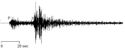
Earthquakes are fairly common in the eastern half of the United States. Four zones of frequent earthquake activity affecting Alabama (right) are the New Madrid Seismic Zone, the Southern Appalachian Seismic Zone, the South Carolina Seismic Zone, and the Bahamas Fracture Seismic Zone.

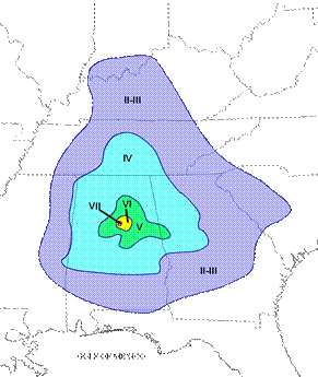
Most of the earthquakes we experience in Alabama are associated with the Southern Appalachian Seismic Zone (an extension of the East Tennessee Seismic Zone) that runs along the Appalachian Mountains from the northeastern corner into the central part of the state and the Bahamas Fracture Seismic Zone in southern Alabama.

earthquakes in alabama


Interactive Earthquake Map of AL

Earthquakes are not uncommon in Alabama. The interactive map to below shows epicenters of historical Alabama earthquakes since 1886 and surface and basement faults. To read more information on individual earthquakes or faults, click the feature on the map.

GIS shapefiles and metadata: Geospatial Hazards Data page.

Historical Earthquakes in Alabama

Fort Payne, 2003

chimney destroyed by Fort Payne earthquake

Building damage caused by the Fort Payne 2003 earthquake included broken windows, minor cracks in masonry (below), and chimneys that collapsed or broke at the top (above). Some schools in the area were closed as a precaution although no structural damage was recorded.

cracked foundation caused by Fort Payne earthquake
seismogram of Fort Payne earthquake

On Tuesday morning, April 29, 2003, a 4.9 magnitude earthquake occurred in DeKalb County, Alabama, 10 miles northeast of Fort Payne. The quake was felt in multiple southeastern states (below). The earthquake was deep enough to suppress significant damage in Fort Payne, the closest city, although the event did damage weaker masonry.

map showing the location of the Fort Payne, AL earthquake
rock fall and scarp caused by Fort Payne earthquake

The Fort Payne magnitude 4.9 quake caused the development of minor landslides such as the one above, sinkholes like the one below and, muddied the underground water supply for the town of Valley Head, causing the pumps to shut down.

sink hole caused by Fort Payne, AL earthquake

Escambia County Earthquake, 1997

map of earthquake location for Escambia County

The second largest quake recorded by seismographs in Alabama occurred on October 24, 1997, in Escambia County (left) and was a 4.9 magnitude event. Effects from the shaking were seen as far away as Lawrence County where a berm around a pond failed, spilling water and fish across a road. Large cracks also developed in sand along a creek (right). Shaking from the quake was felt into Mississippi.

large cracks in sand along a creek cause by Escambia County earthquake


Irondale Earthquake, 1916

The largest known earthquake in Alabama happened October 1916 in northern Shelby County (below). Intensity was estimated to be a VII on the Modified Mercalli Scale, indicating a moderate earthquake. Geologists estimate the magnitude was about 5.1.

location map for the Irondale earthquake of 1916

Seismic Stations

The U.S. Geological Survey (USGS) installed a broadband seismic station in Bibb County in June 2001. The station (photos below) was funded through a grant from the AEMA and arranged by an agreement between AEMA, the USGS, and the Geological Survey of Alabama (GSA) and is part of the Advanced National Seismic System (ANSS) coordinated by the USGS. The site for the station is located near the middle of the state in Bibb County in the southernmost exposure of hard Paleozoic rocks.

computer equipment in the seismic station

The station is able to monitor even small earthquakes that generally go unnoticed but may be precursors of future larger quakes. Information from the sensors goes to an onsite computer (left), which then relays the information by satellite (far right) to USGS headquarters in Golden, Colorado.

seismograph sensors
building that houses the seismograph

The station’s sensors are placed 4 feet underground and can sense everything from vehicles passing by to earthquakes on the other side of the earth. The two sensors at the station are buried in large water-tight containers. A small shed houses the accompanying electronics (above middle and right).


map of seismograph locations

Alabama Seismic Stations

Curious to see what seismic stations in Alabama are recording today? Click on one of the seismic station links below to go to its corresponding helicorder (a compiled record of vibrations recorded by the station).

  • BRAL, Brewton, AL (USNSN, Broadband) – S AL
  • LRAL, Lakeview Retreat, AL (USNSN, Broadband) – SW Central AL
  • FPAL, Ft Payne, AL (CERI, Broadband) – NE AL
  • FPAL, Ft Payne, AL (CERI, Strong Motion) – NE AL
  • PWLA, Pickwick Lake, AL (CERI, Shortperiod) – NW AL
  • PWLA, Pickwick Lake, AL (CERI, Strong Motion) – NW AL
  • PLAL, Pickwick Lake (SLU, Broadband) – NW AL
  • Y49A, Blount Mountain (N4 E, Broadband) – NE Central AL
  • X48A, Hartselle, AL (N4 E, Broadband) – Central N AL
  • Z47B, Carrollton, AL (N4 E, Broadband) – Central W AL
  • 250A, Grady, AL (N4 E, Broadband) – SE AL

Additional Alabama Earthquake Information


Earthquake Hazards Map

To produce your own Earthquake Hazards Map such as the one to the right, click here to go to the USGS Custom Hazards Mapping tool. The colors on the map refer to an estimate of the probability of exceeding a certain level of ground shaking in percent g (gravitational force) in 50 years. This is dependent on magnitudes and locations of likely earthquakes, occurrence frequency, and properties of the rocks and sediments of the area.

For additional information on how these maps are generated, click here to go to the USGS webpage on “Earthquake Hazards 101.”

For the U.S. National Seismic Hazards Maps 2008 edition and 2010 revisions, click here.

earthquake hazards map

Seismic Engineering

For seismic design information for engineers, please refer to the USGS webpage "Seismic Design Maps and Tools for Engineers."

Earthquake Probability Mapping

For earthquake probability mapping of an area of interest in Alabama, click here to refer to the USGS 2009 Earthquake Probability Mapping page. The page requires input of a latitude/longitude of interest (such as for that of a city) and an area map (such as the one to the right) is produced showing estimated earthquake probabilities computed from the source model of the 2008 USGS-National Seismic Hazard Mapping Project (NSHMP) update.

For documentation on the USGS online program that produces the maps such as the one to the right, click here.

earthquake probability map of alabama


Alabama Earthquake Notification

email graphic

If you would like to receive a text message or email when an earthquake occurs in Alabama, click here to sign up through the USGS automated Earthquake Notification System.

Additional Questions?

If you are looking for additional Alabama-specific earthquake information not found on these pages, please contact {{Director.Name}}, {{Director.Phone}}. For earthquake information specific to other states, please refer to that state’s geological survey or the USGS.