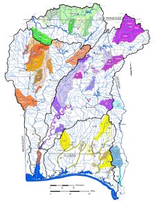
Alabama Rivers and Streams Network including Connectivity (ARSNiC)
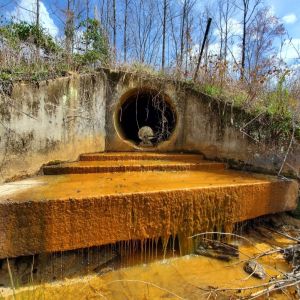
Perched Culvert
Stream Barrier Assessment
Many aquatic species are at risk due to the degradation of water quality and impairments to habitat. A major source of documented habitat impairment for aquatic fauna is a lack of longitudinal stream connectivity caused by anthropogenic interactions primarily being in-stream barriers related to perched (elevated) culverts. Longitudinal connectivity of stream reaches and channels is necessary for many species to access spawning grounds and allow for adequate gene flow among populations in these reproductive areas. The fracturing of stream longitudinal connectivity also impacts fluvial regimes that influence the geomorphic watershed dynamics.
Impact of Stream Barriers:
- Altered flow patterns leading to increased erosion
- Destabilization of stream banks
- Deposition of excessive sediment
- Bed scouring and flooding
- Degradation of public drinking water supplies
- Infrastructure failure and increased utility costs
GSA is leading the effort to identify potential stream passage issues by founding an aquatic connectivity team, in collaboration with the Southeast Aquatic Resource Partnership (SARP) and other Alabama Rivers and Streams Network (ARSN) members. The mission of the team is to restore connectivity, habitat, and ecological functions to streams in the state by identifying, assessing, and prioritizing barriers to aquatic organism passage.